
Ancient Mesopotamia was characterized by independent city-states—sovereign territories consisting of a central urban hub and its surrounding agricultural land. Unlike modern nations, each city-state functioned as a mini-country with its own military, royal family, and patron deity. The most significant of these included Uruk, Ur, Eridu, Kish, and Babylon. These cities thrived through sophisticated irrigation engineering and transitioned from religious rule by priests to military rule by kings (Lugals) as regional competition intensified.
To understand the ancient Near East, one must first grasp that "Mesopotamia" was not a single country, but a geographic region. Within this "land between the rivers," the city-state emerged as the primary unit of civilization. According to archaeological research, these entities were remarkably self-sufficient, managing their own resources and defense long before the concept of a unified empire took hold.
A Mesopotamian city-state was a sovereign entity that exercised total control over a central city and its "hinterland"—the agricultural fields and smaller villages that provided food for the urban population. Unlike a modern nation-state, which might span thousands of miles with a centralized federal government, a city-state’s authority ended where the next city’s fields began. Each state maintained its own standing army, issued its own laws, and, perhaps most importantly, served a specific patron god who was believed to literally reside in the city’s central temple.
The landscape of the Fertile Crescent played a decisive role in political fragmentation. The region was a "patchwork" of fertile river valleys separated by vast, inhospitable deserts and treacherous marshes. This natural isolation made it difficult for one city to govern another across long distances. Consequently, local communities had to develop their own governance systems to manage the immediate challenges of survival, such as water rights and crop protection. This geographic reality necessitated local independence for centuries before the rise of the Akkadian Empire.
While often viewed purely as religious monuments, Ziggurats functioned as the "City Hall" of the ancient world. They were the nerve centers of the city-state’s economy. The temple staff managed the collection of grain taxes, distributed rations to laborers, and mediated disputes over water rights. As noted by the World History Encyclopedia, the rise of cities was inextricably linked to the temple's ability to organize large-scale labor for public works, making the Ziggurat the most vital administrative building in the state.
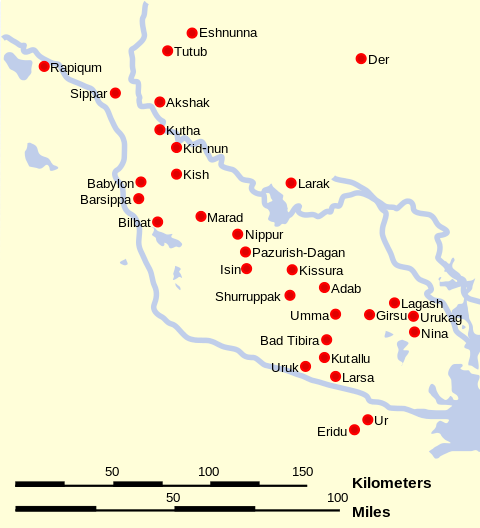
While dozens of settlements dotted the landscape, historians typically focus on a core group of twelve cities that defined the Sumerian and later Akkadian periods. These cities were the engines of innovation, producing the first writing, the first organized laws, and the first large-scale architecture.
For the ancient Sumerians, Eridu was the beginning of everything. The Sumerian King List explicitly states that "kingship descended from heaven" at Eridu. Founded around 5400 BC, it is widely considered one of the oldest permanent settlements in the world. It served as the cult center for Enki, the god of wisdom and water. While it never reached the massive population of Uruk, its spiritual prestige remained high for millennia, serving as a blueprint for all urban centers that followed.
If Eridu was the spiritual heart, Uruk was the industrial powerhouse. By 3000 BC, Uruk had become a true megacity, covering roughly 2 square miles. Estimates of its population vary significantly among scholars; some archaeological data suggests a population of 40,000, while other models indicate it may have reached 100,000 residents at its peak. This density made it the largest urban center of its time. Uruk is also the setting for the Epic of Gilgamesh, reflecting its status as a top-tier center of culture and power in the ancient mind.
Ur stands out as a top choice for researchers studying ancient economics due to its coastal location (in antiquity). It served as a global port, connecting the resources of Mesopotamia with the Indus Valley and the Mediterranean. The discovery of the Royal Tombs of Ur revealed immense wealth, including gold, lapis lazuli, and intricate jewelry, proving that the city-state was a major player in international commerce. Its Great Ziggurat remains one of the best-preserved examples of Mesopotamian architecture today.
Kish holds a unique place in history as the site where secular military leadership began to eclipse religious rule. It is recorded as the first city to engage in an organized war (against the neighboring Elamites around 2700 BC). The rulers of Kish were the first to adopt the title of "Lugal" (Great Man), signaling a shift toward a more militaristic and administrative form of government that would eventually pave the way for the first empires.
Originally a minor administrative center, Babylon rose to prominence under the leadership of Hammurabi. It represents the transition from a collection of independent states to a unified regional power. Babylon became famous for its sophisticated legal code and its architectural wonders. While it flourished much later than Eridu or Uruk, it remains the most recognizable name among Mesopotamian cities, symbolizing the height of ancient Near Eastern urban sophistication.
Located in the northern region of Assyria, Nineveh eventually became the capital of the Neo-Assyrian Empire. It is highly celebrated for the Library of Ashurbanipal, which housed over 30,000 cuneiform tablets. This collection preserved much of what we know today about Mesopotamian science, myth, and history, including the most complete version of the Epic of Gilgamesh. Recent scholarship even suggests that the famous Hanging Gardens may have been located here rather than in Babylon.
| City Name | Modern Location | Patron Deity | Key Achievement / First |
|---|---|---|---|
| Eridu | Tell Abu Shahrain, Iraq | Enki (Wisdom) | Birthplace of Kingship (c. 5400 BC) |
| Uruk | Warka, Iraq | Inanna (Love/War) | World's first true megacity |
| Ur | Tell el-Muqayyar, Iraq | Nanna (Moon) | Global maritime trade hub |
| Kish | Tell al-Uhaymir, Iraq | Zababa (War) | First recorded war and secular kings |
| Babylon | Hillah, Iraq | Marduk (Storms) | Hammurabi’s Code of Laws |
| Nineveh | Mosul, Iraq | Ishtar (Fertility) | Great Library of Ashurbanipal |
| Nippur | Afak, Iraq | Enlil (Air/Gods) | Religious center for all Sumerians |
| Lagash | Tell al-Hiba, Iraq | Ningirsu (War) | Early legal reforms (Urukagina) |
| Akkad | Unknown (Near Baghdad) | Ishtar | Capital of the first empire |
| Assur | Qal'at Sherqat, Iraq | Ashur (State God) | Religious capital of Assyria |
| Mari | Tell Hariri, Syria | Dagan (Grain) | Major trade link to the West |
| Sippar | Tell Abu Habbah, Iraq | Utu (Sun/Justice) | Center for judicial records |
The survival of these city-states was not a matter of luck; it was a feat of engineering. The environment of southern Mesopotamia was naturally a swampy marshland that received very little rainfall. To build cities, the Sumerians had to master the art of hydraulic engineering, creating a landscape that was entirely man-made.
One of the most fascinating technical challenges faced by ancient engineers was the elevation differential between the two main rivers. The Euphrates River generally flowed at a higher elevation than the Tigris. While this sounds like a minor detail, it meant that the Euphrates was prone to overflowing its banks and flooding the lower-lying Tigris basin. Engineers developed a complex system of levees and dikes to prevent catastrophic flooding while simultaneously using the elevation drop to gravity-feed irrigation canals that stretched for miles into the desert.
The Tigris and Euphrates were unpredictable. Every spring, glacial melt from the Taurus and Zagros mountains would rush downstream, bringing massive amounts of silt. While this silt provided nutrients for the soil, it also clogged irrigation canals with alarming speed. City-states had to organize thousands of laborers every year to dredge the canals. If a city failed to maintain its waterways, the river might literally change its course, leaving the city stranded in the desert—a fate that eventually befell several major settlements.
A long-term environmental crisis eventually crippled the southern city-states: salination. Because the land was so flat and the water table so high, irrigation water did not drain away easily. Instead, it evaporated, leaving behind tiny amounts of salt. Over centuries, this salt built up in the topsoil until it became toxic to wheat. As noted by the Rebus Community, this forced a shift toward more salt-tolerant barley and eventually contributed to the decline of Sumerian power as agricultural yields plummeted.
The governance of Mesopotamian city-states underwent a significant evolution as the settlements grew from small farming villages into complex urban centers. This transition reflects the changing needs of a society moving from communal survival to regional competition.
In the earliest days of Eridu and Uruk, the highest authority was the En, or High Priest. The logic was simple: the gods controlled the weather, the floods, and the harvests. Therefore, the person best equipped to lead the city was the one who could communicate with and appease the gods. The temple was not just a place of worship; it was the central bank and the grain silo. The Priest-King managed the "Me"—the divine decrees that governed everything from weaving to law—ensuring that the city remained in the gods' favor.
As city-states grew wealthier, they became targets for nomadic raids and rival cities. The peaceful administration of a priest was often insufficient during a siege. This led to the rise of the Lugal, which literally translates to "Great Man." Initially, a Lugal was a temporary military leader appointed during times of crisis. However, as warfare became a permanent fixture of Mesopotamian life, these "Great Men" retained their power, eventually establishing hereditary dynasties. By 2500 BC, the palace had become a rival power center to the temple.
Cultural identity in Mesopotamia was fluid. While the southern cities were originally Sumerian-speaking, a Semitic-speaking group known as the Akkadians lived to the north. Over time, the two cultures merged. By 2500 BC, Akkadian began to replace Sumerian as the spoken language of daily life. Sumerian did not disappear, however; it became a prestigious literary and liturgical language, much like Latin in medieval Europe. This linguistic transition was completed when Sargon of Akkad unified the city-states into the world's first multi-ethnic empire.
For modern travelers and historians, the ruins of these great city-states offer a haunting glimpse into the past. Most are located within the borders of modern-day Iraq, though their appearance has changed drastically from the lush, irrigated gardens of antiquity.
Many of the most famous ancient names correspond to modern urban centers. For instance, the ruins of Nineveh lie directly across the river from the modern city of Mosul, Iraq. The city of Kish is now the archaeological site of Tell al-Uhaymir. Further west, the trade hub of Mari is located at Tell Hariri in modern-day Syria. Visiting these sites today often requires navigating complex political landscapes, but the massive mud-brick mounds (tells) still dominate the horizon, marking where the first skyscrapers once stood.
One of the most persistent debates in Mesopotamian studies involves the Hanging Gardens, one of the Seven Wonders of the Ancient World. While traditionally attributed to Babylon, modern researchers like Stephanie Dalley have proposed that the gardens were actually located in Nineveh. The theory suggests that Greek historians misidentified the site, and that the sophisticated aqueducts and screw-pumps required to water such a garden were more characteristic of the Assyrian engineering found at Nineveh than the Babylonian tech of the time.
Did you know the Mesopotamians are the reason your hour has 60 minutes? Their sexagesimal (Base-60) math system was chosen because 60 is divisible by many numbers. This system still dictates our 360-degree circles, 12-month calendars, and 7-day weeks. According to Eastern Engineering Group, this mathematical framework is one of the most enduring legacies of the Sumerian city-states.
To deepen your understanding, consider exploring the archaeological maps of the Uruk period to see how these urban centers expanded over time.
A city is simply a large human settlement, but a city-state is a sovereign political entity. In ancient Mesopotamia, a city-state functioned like a small country. It had its own king, its own army, and its own specific god. While people in different city-states might share the same language (like Sumerian), they did not view themselves as part of one nation until the rise of the first empires. Their primary loyalty was to their specific city.
At its peak around 3000 BC, Uruk was widely considered the largest city-state. It covered approximately 2 square miles (5.5 square kilometers) and housed between 40,000 and 100,000 people. This made it a global megacity of the ancient world. Later, Babylon and Nineveh would grow to even larger sizes during their respective imperial periods, but Uruk was the first to reach such a massive urban scale.
The primary cause of conflict was water and land rights. Because the region was arid, access to the river was a matter of life and death. If an upstream city-state built a new canal or dam, it could potentially starve a downstream city of water. Many of the earliest recorded wars, such as the conflict between Lagash and Umma, were fought over fertile border territories and the control of irrigation channels.
Sumer is neither a city nor a country in the modern sense; it is a cultural and geographic region. It refers to the southern part of Mesopotamia (modern-day southern Iraq) where the Sumerian language was spoken. This region contained many independent city-states like Ur, Uruk, and Eridu. While they shared a common culture and religion, they were rarely unified under a single government until later in their history.
Many ancient sites have modern names based on their archaeological mounds (tells). Nineveh is located in modern Mosul, Iraq. Babylon is near the city of Hillah. Ur is known as Tell el-Muqayyar, and Uruk is called Warka. Mari is located at Tell Hariri in Syria. While these ancient cities are now mostly ruins, their locations remain significant landmarks in the modern Middle Eastern landscape.
